Station Fire - Los Angeles, 2009
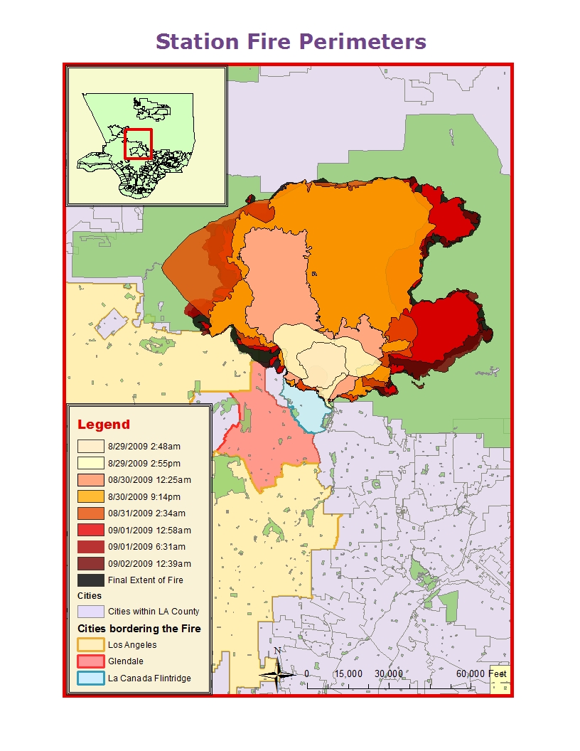
The fire that raged through the Angeles National Forest almost three years ago left a great deal of damage. The Station Fire is the largest fire in Los Angeles County's history, burning through 160,577 acres of national forest (NOAA, 2010). In addition to destroying over 150,000 acres of vegetation, it destroyed 18 homes and took the lives of two firefighters (Garrison, Zavis, Mozingo, 2009). The fire was not ignited due to natural causes but was the result of arson - a deliberate act of setting fire to the area. In the first map, titled "Station Fire Perimeters" a dynamic element of time shows how the fire spread. In a matter of 4 days it consumed a large portion of the Angeles National Forest and even posed a real threat to the cities of Glendale, Los Angeles and La Canada Flintridge with the flames licking at the northern tips of these populated areas. While the fire did a lot of damage, its devastating effects were felt long after the fire had been contained. 

While there are many after-effects following the event of a fire, the most immediate effect is soil erosion. Soil erosion is not only a problem when trying to restore a burnt area, but can result in mudslides and flooding, which were exceptionally harrowing during the wet season the following year. According to the Los Angeles Times, several mudslides and floods affected hundreds of residents in Los Angeles County, with the brunt of the damage felt by residents in the foothills (Lin, Kim, Vives, 2010). In February of 2010, a mudslide damaged 43 homes in La Canada Flintridge and La Crescenta. It was so forceful it moved a 10-ton boulder, dented cars and did structural damage to a number of homes. Because soil erosion was one of the more extreme residual effects of the Station Fire, I decided to make it the focus of my theme map.
As a fire moves through an area, it burns the litter on the ground, the vegetation and even the roots of plants (Moench, Fusaro, 2012). Vegetation is responsible for mitigating the effects of rainfall and soil erosion. It absorbs excess water, reduces runoff and keeps soil in place. The presence of healthy vegetation is a crucial element in any environment, specifically one that is inhabited by people, because it can lessen and even prevent tragic flooding and mudslide events. After the Station Fire, the soil erodibility was high because soil structure was damaged, litter was non-existent and permeability was low. After being exposed to intense heat for a prolonged period, soil has a tendency to repel water. This is a condition called hydrophobicity (Moench, 2012). The slope length gradient was high because the burn area is located in a mountainous region with steep slopes. Vegetation was non-existant because it had been destroyed a few months earlier and rainfall was present and acute due to extreme storms.
All of the elements were in place to create hazardous conditions that put the lives of residents living in the foothills and elsewhere at risk. According to the Los Angeles Times, unexpected storm conditions meant that the necessary evacuation orders had not been made, along with other precautions (Lin, Kim, Vives, 2010). While no lives were lost, damage could have been prevented if officials were more prepared. Funding should be allocated for restoration projects in burn areas, restoring vegetation to the area. Natural and artificial buffers should be created to deal with the after effects of fires, especially large scale ones such as the Station Fire.
Works Cited
FRAP Data: Post Fire Erosion Potential. (n.d.). FRAP - Fire and Resource Assessment Program. Retrieved June 9, 2012, from http://frap.cdf.ca.gov/data/frapgisdata/download.asp?rec=perod
Garrison, J., Zavis, A., & Mozingo, J. (2009, August 31). Station fire claims 18 homes and 2 firefighters. Los Angeles Times. Retrieved June 6, 2012, from http://articles.latimes.com/2009/aug/31/local/me-fire31
Lin, R., Kim, V., & Vives, R. (2010, February 7). 'Niagra' of mud hits homes. Los Angeles Times. Retrieved June 10, 2012, from http://articles.latimes.com/2010/feb/07/local/la-me-rain7-2010feb07
Moench, R., & Fusaro, J. (n.d.). Soil Erosion Control after Wildfire. Colorado State University Extension. Retrieved June 11, 2012, from http://www.ext.colostate.edu/pubs/natres/06308.html
State of the Climate | Wildfires | Annual 2009. (n.d.). NCDC: * National Climatic Data Center (NCDC) *. Retrieved June 11, 2012, from http://www.ncdc.noaa.gov/sotc/fire/2009/13

No comments:
Post a Comment